Evaluating satellite observation for predicting topsoil carbon
The STEROPES project aims to push forward the use of satellite time series, such as those made available by the European Space Agency, in order to update maps. There is a need to spatially estimate and monitor soil properties for decision support and land management.

Pushing the use of satellite time series forward
STEROPES, named after a cyclop from the Ancient Greek mythology, stands for “stimulating novel technologies from earth remote sensing to predict European soil carbon”. The overall context of the project STEROPES stems from the need to spatially estimate and monitor soil properties, and especially soil organic carbon (SOC) content, for decision support and land management.
Collecting soil samples is time-consuming and labour extensive. In the last decades, for the purpose of providing maps of for example SOC, Digital Soil Mapping (DSM) has been carried out, starting from a number of soil sample locations with standard chemical analyses of SOC in the lab, to construct spatial, geostatistical models. Morphometric data (such as elevation and slope) are often incorporated into this modelling, in conjunction with covariates derived from earth observation such as the vegetation index NDVI. STEROPES aims to push forward the use of satellite time series, such as those made available by the European Space Agency, in order to update maps. (Fig. 1. Overall context and STEROPES motivation)
The overall background for using remote sensing is the fact that in addition to have spatial structure, soil properties, and particularly SOC, have spectral features in a number of wavebands from the visible, near-infrared and shortwave infrared that enable to construct spectral models, that is models relating soil reflectance with the considered soil property (Fig. 2).
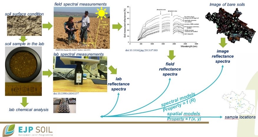
Fig. 2. Overall STEROPES approach
The project STEROPES will:
- Assess robustness of spectral models according to agroecosystems /soil types ; this at two spatial levels, regional (hundreds to thousands of km²) and local (a farm or a field)
- Assess either disturbing or influencing soil surface factors and account for them: soil moisture, soil texture, dry and green vegetation, salinity
- Incorporate the results into spatial models for recommending best performing methods ; also, whenever possible, perform uncertainty assessment.
The project overall approach relies on the wide diversity of soil types and agricultural systems enabled by the STEROPES consortium: we are indeed 14 countries (Fig. 3).
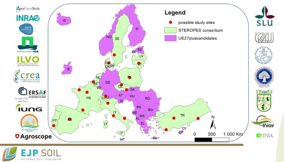
Fig. 3. Map of STEROPES consortium and possible study sites
The STEROPES project will build spectral models, then focus on the disturbing/influencing factors, and finally operate data synergy, and incorporate remote sensing into spatial models. A number of relevant outcomes are expected: first, a step-forward for DSM of SOC content, a step-forward for the remote sensing of soils; second, enhancement of transnational collaboration and impact on approaches for carbon balance accounting; and finally, opening up of links with stakeholders for an enhanced use of remote sensing.
Additional information:
Go to the project website, click here, and read more on the overall EJP SOIL website.
Contact for more information : emmanuelle.vaudour@agroparistech.fr; johanna.wetterlind@slu.se