Strategies for connected landscape elements to reduce water erosion
Modelling and scaling can help us understand how fields, rivers and streets are connected. This insight can help reduce damages from water erosion impacts and provide recommendations for improved mitigation strategies.

Water erosion reduces soil quality and causes ecological and economical damages to the environment, to farmers and the society by loss of water storage capacity, organic carbon and essential nutrients, and by their transfer into aquatic environments and urban areas.
Click here to watch the SCALE project video.
Gaining a better understanding of sediment connectivity in agricultural landscape systems i.e. fields, rivers, ditches, streets, forests, grassland areas etc., can improve the impact of both in-field and off-site mitigation strategies and thereby reduce the off-site damages of soil erosion from agricultural land.
The SCALE project focus on ‘sediment connectivity‘, indicating, how easy it is for soil to flow from one place to another place without hindrance, and how strong for instance fields, rivers, streets are connected to each other.
To gain new knowledge, SCALE looks at current state-of-the-art of connectivity principles in modelling and legal standards. It is an objective to harmonise data sets and up- and downscaling methods. Measures and modelling approaches are evaluated and frameworks with mitigation measures and best management practices will be developed.
How does down scaling and up scaling techniques contribute in research?
Scales are very important in the context of sediment connectivity, since they describes the spatial and sometimes temporal dimensions on how we look on soil erosion processes. A very detailed spatial scale would be the plot scale, which describes spatially rather small area (ca. 100 m²) on which mostly very detailed experiments are conducted to see how erosion initiates and which properties might reduce the probability of erosion to happen (e.g. vegetation cover by grass or certain crops). The next higher spatial scale would be the field scale, where not only parts of an agricultural field are of interest, but how certain erosion processes behave on the entire field (e.g. overland flow).
Another important spatial scale would be the catchment scale, where many fields and other landscape elements within a hydrological watershed are considered. Usually, the detail of information (e.g. by measurements) decrease the coarser the spatial scale is or in other words: the more we “zoom” out, the less information we have. However, coarser scales provide valuable information for larger areas and are often able to provide the “big-picture”. Thus, all spatial scales are of interest. The methods of up-scaling, e.g. going from a finer spatial scale like a field to a coarser spatial scale like a catchment and down-scaling (vice versa) aim to transfer information from one spatial scale to the next higher or lower. The knowledge from a particular scale can be used to derive conclusions for the next higher or lower scale.
How is modelling used for developing erosion mitigation strategies?
Models are a simplification of reality with which SCALE try to reconstruct or simulate certain physical behaviours under distinct environmental conditions. Hence, soil erosion modelling is the application of a large variety of models that are capable of simulating, indicating or even predicting soil erosion and interrelated processes such as overland flow, water movement in the soil, etc.
With modelling, we are able to simulate soil erosion on different scales and to simulate, what will happen if certain environmental and agricultural conditions are fulfilled. This allows the estimation of how effective certain soil erosion mitigation measures will be and thus draw conclusions on what should be improved, leading to recommendations for farmers, practitioners and decision makers.
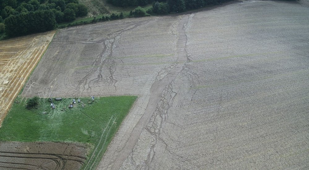
Photo: Erosion damage after heavy rainfall event in Petzenkirchen, Austria. Photo by Elmar Schmaltz.
Guidelines to farmers, consultants and regulatory bodies
Testing different approaches to the harmonisation of datasets and parameters as well as up- and downscaling techniques and inclusion of connectivity elements in soil erosion models will improve the coordination of mitigation strategies in connected landscape systems.
SCALE aims to provide guidelines to farmers, consultants and regulatory bodies, which will improve the understanding of erosion risk and provide decision support in implementing targeted mitigation measures tailored to their specific agricultural landscape.
SCALE has 13 partners from 9 countries across Europe. This provides knowledge about erosion issues in several different agricultural landscapes across Europe, which is vital to the project.
For further information:
SCALE Coordinator: Dr. Elmar M. Schmaltz, Federal Agency for Water Management, Institute for Land and Water Management Research, Head of Department Watershed Hydrology and Erosion, Austria. Email: elmar.schmaltz@baw.at
SCALE Co-coordinator, Dr. Lisbeth L. Johannsen, Federal Agency for Water Management, Institute for Land and Water Management Research, Austria. Email: lisbeth.johannsen@baw.at
http://www.baw.at/en/wasser-boden-en.html