SOIL-ES
| Start: | - (External Call project) |
| Duration: | 36 |
| Aim: | SOIL-ES aims to develop and adapt tools for mapping and monitoring soil ecosystem services (SES) in agricultural and livestock systems, considering soil processes and landscape characteristics at multiple scale, in areas where there is sustainable intensification, which is defined as a system where agricultural yields are increased without adverse environmental impact and expansion of agriculture to new areas. |
| Contact: | Coordinator Dr. Rachel Bardy Prado, Brazilian Agricultural Research Corporation (Embrapa), Brazil Mail: rachel.prado@embrapa.br |
| Website | - |

Although the conventional management practices (e.g. use of synthetic chemicals, fertilizers, tillage systems, monocultures) have been used to feed the fast-growing human population, their negative impacts on the ecosystem services (ES) that sustain human well-being created the need to move towards more sustainable management practices.
Adopting an ecosystem approach in agricultural production leads to sustainable production. However, soils have been frequently neglected when using an ES approach, despite their multifunctionality and their role in providing multiple ES. Soil management is a key factor for both ES maintenance by agricultural systems and for achieving sustainable intensification (SI), which is defined as a system where agricultural yields are increased without adverse environmental impact and expansion of agriculture to new areas.
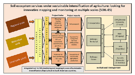
SOIL-ES aims to develop and adapt tools for mapping and monitoring soil ecosystem services (SES) in agricultural and livestock systems, considering soil processes and landscape characteristics at multiple scale, in areas where there is SI (figure 1 to the left).
The consortium is composed of researchers from different countries of South America that use different approaches to study the impacts of agriculture on ES, focusing on soils. The consortium will also receive the contribution of a team of French researchers, which has already been studying areas of large agricultural production in Brazil.
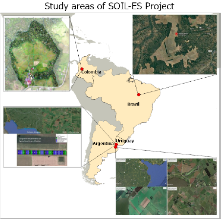
The first study area is the Matopiba region, a growing agricultural production area, mainly grains and livestock in Brazil.
The second and third study areas comprehend extensive livestock production in Argentina and Uruguay (Pampa).
The fourth is a mosaic landscape with coffee and other crops, pasture and forest in the central Andes in Colombia.
Figure 2 to the right presents the location and illustration of these areas, where SI systems represent a promising alternative to the current agricultural systems that has historically resulted in the loss of many ES.
The proposal considers three scales: the first (a) is the local (plot) scale, where we seek to identify key indicators and integrate them into a single protocol (Index), capable of monitoring the impacts of SI in agricultural systems on SES. The second scale (b) is at watershed level, where the objective is to obtain a single protocol for mapping SES and sustainable intensification practices. At this level, remoting sensing and modeling tools it will be applied, aiming to support watershed land and water management, schemes of payment for ecosystem services (PES) and carbon markets. The third is (c) at regional scale, which seeks to develop a protocol for zoning SES and their ambience, gathering information from available soil surveys and landscape features, that can support rural landscape planning.
Workshops are scheduled, at least one online (at the beginning of the project) and one in-person for validation of results with local actors (from the middle to the end of the project), as well as training throughout the project in tools applicable to different work scales.
SOIL-ES will deliver an integrated, validated and auditable tool for SES monitoring and mapping. Protocols will be delivered together with guidelines for their application, whether by farmers at the local scale or by decision-makers and governments at the watershed and regional scales.


Project partners
Country | Organization |
Uruguay | Instituto Nacional de Investigación Agropecuaria (INIA) |
Argentina | National Institute of Agricultural Technology (INTA) |
Colombia | Quidio |
France | French National Centre for Scientific Research (CNRS) |